Pas encore de commentaire.


S'informer sur les lieux tagués dans cet album
Les destinations
|
| Tous droits réservés à l'auteur BENREJEBWAJDI | Faire des dons gratuits
Financez gratuitement les associations de votre choix en publiant des photos de voyage !
|
Commentaires borhen
Ajouter un commentaire
Avis posté le 28/08/2014 par wazzaa
CLIMATE
Tunisia's climate is temperate in the north, with mild rainy winters and hot, dry summers. The south of the country is desert. The terrain in the north is mountainous, which, moving south, gives way to a hot, dry central plain. The south is semiarid, and merges into the Sahara. A series of salt lakes, known as chotts or shatts, lie in an east-west line at the northern edge of the Sahara, extending from the Gulf of Gabes into Algeria. The lowest point is Shatt al Gharsah, at 17 metres (56 ft) below sea level and the highest is Jebel ech Chambi, at 1,544 metres (5,066 ft). According to the customs of the Troglodytes, to avert perishing by dehydration in the hot sand dunes, the locals drink a good quantity of water, eat some food, then drink a measure of olive oil. This seals the stomach, so that the water is released slowly into the system. After consumption, they do not eat or drink until the following day,
Le 30/08/2014
Autres albums suggérés


Suivre
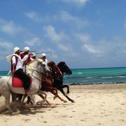
L'endroit a l'air sympa... Mais elle est un peu pixelisée l'image, non ? :p
Signaler un abusLe 30/08/2014